Open theses and project topics
Details about the currently avaliable topics can be found on SiROP. The categories (Bachelor Thesis, Master Thesis and Semester Project) are primarily recommendations. Depending on the topic, it might be possible to adapt the scope to make it suitable for a different type of thesis/project.
Understanding Effects of GPS Data on Weather Foundation Models

Existing weather foundational models can be enriched with data from different modalities, like GPS. The effects of this data on model accuracy are unclear. This projects aims to disentangle the influence of different data sources on prediction of climate variables (e.g., humidity or El Niño–Southern Oscillation) using explainable AI methods and interactive visualization.
Keywords
Machine learning, weather, foundational models, explanable AI
Labels
Bachelor Thesis , Master Thesis , ETH Zurich (ETHZ)
Description
Goal
Contact Details
More information
Published since: 2025-10-27
Organization Space Geodesy (Prof. Soja)
Hosts Soja Benedikt
Topics Engineering and Technology , Earth Sciences
Feasibility of Using Global Ground-Based GNSS PWV as an Early-Warning Signal for ENSO

Precipitable Water Vapor (PWV), retrieved from global ground-based GNSS networks, offers multi-decadal, continuous, and weather-independent observations of atmospheric moisture with high accuracy. Because tropospheric moisture anomalies are tightly coupled to large-scale ocean-atmosphere variability, this project investigates the feasibility of using GNSS-derived PWV as an early-warning signal for the El Niño–Southern Oscillation (ENSO). We will assemble a global PWV dataset from GNSS stations spanning more than 20 years and analyze its relationship to standard ENSO indices (e.g., MEI.v2, ONI). After quality control and anomaly extraction, we will quantify spatial correlation patterns, lead–lag structures, and latencies between PWV and ENSO at station and regional scales.
Keywords
GNSS PWV, ENSO, early warning, lead–lag correlation
Labels
Semester Project , Bachelor Thesis , Master Thesis , ETH Zurich (ETHZ)
Description
Goal
Contact Details
More information
Published since: 2025-10-27
Organization Space Geodesy (Prof. Soja)
Hosts Soja Benedikt
Topics Engineering and Technology
Long-term ionospheric VTEC modeling with uncertainty quantification

Accurate global ionospheric modeling is important in enhancing GNSS navigation and positioning. Existing studies primarily focus on deterministic predictions and often overlook uncertainty quantification. However, uncertainties are also important as they allow weighting the corresponding observations during data fusion or parameter estimation.
Keywords
Probabilistic neural network, uncertainty, vertical total electron content (VTEC), GNSS
Labels
Semester Project , Master Thesis , ETH Zurich (ETHZ)
Description
Goal
Contact Details
More information
Published since: 2025-10-24
Organization Space Geodesy (Prof. Soja)
Hosts Soja Benedikt
Topics Engineering and Technology
GNSS and Madrigal STEC Analysis

This project compares slant Total Electron Content (STEC) derived from CAMALIOT GNSS processing with independent measurements from the Madrigal database to identify and correct systematic biases.
Keywords
GNSS, STEC, Ionosphere, Madrigal
Labels
Bachelor Thesis , ETH Zurich (ETHZ)
Description
Goal
Contact Details
More information
Published since: 2025-10-24
Organization Space Geodesy (Prof. Soja)
Hosts Soja Benedikt
Topics Engineering and Technology
Toward more accurate regional ML-based slant wet delay models

Slant wet delay (SWD) is a critical error source for space geodesy techniques such as GNSS and VLBI. To solve this issue, ETH Space geodesy group did the first attempt of using machine learning (ML) to develop a global empirical SWD model. However, it is not yet optimally modeled for regional applications, which is very important in practice. Therefore, this project will advance the existed pre-trained global empirical SWD model toward accurate regional models through targeted fine-tuning. Further improvements are expected for GNSS data processing.
Keywords
slant wet delay; machine learning; ray-tracing; GNSS meteorology; regional fine-tuning; transfer learning; extreme weather
Labels
Semester Project , Master Thesis , ETH Zurich (ETHZ)
Description
Goal
Contact Details
More information
Published since: 2025-10-24
Organization Space Geodesy (Prof. Soja)
Hosts Soja Benedikt
Topics Engineering and Technology
Ray Tracing algorithm for moving platforms

This thesis will focus on developing and testing an efficient ray-tracing algorithm to simulate GNSS signal propagation from moving platforms such as drones over the Zurich metropolitan area. The aim is to model atmospheric signal delays under dynamic conditions and support the retrieval of water vapour from kinematic GNSS measurements.
Keywords
GNSS, atmospheric water vapour, ray tracing, moving platforms, drones, tropospheric delay
Labels
Bachelor Thesis , ETH Zurich (ETHZ)
Description
Goal
Contact Details
More information
Published since: 2025-10-20
Organization Space Geodesy (Prof. Soja)
Hosts Soja Benedikt
Topics Engineering and Technology
Design and optimization of new LEO satellite constellations for GNSS radio occultation-based tropospheric monitoring

This thesis focuses on designing optimal Low Earth Orbit (LEO) satellite constellations for GNSS radio occultation (RO) observations aimed at tropospheric monitoring. The main objective is to develop and assess orbital configurations that enhance the density and geometry of RO observations for use in tropospheric analysis methods, e.g. tomography-like approach or Planetary Boundary Layer monitoring.
Keywords
LEO constellation design, GNSS radio occultation, troposphere monitoring, orbit simulation, remote sensing
Labels
Semester Project , Master Thesis , ETH Zurich (ETHZ)
Description
Goal
Contact Details
More information
Published since: 2025-10-20
Organization Space Geodesy (Prof. Soja)
Hosts Soja Benedikt
Topics Engineering and Technology
Simulation of GNSS coordinate time series with machine learning

Coordinate time series derived from Global Navigation Satellite System (GNSS) stations are fundamental for establishing and maintaining the International Terrestrial Reference Frame (ITRF). These time series exhibit not only linear trends and white noise but also colored noise components, which is chanllenging to be modeled with mathematical models. Recent advances in machine learning provide new opportunities to simulate and better understand the complex temporal behavior of GNSS coordinate time series.
Keywords
GNSS, coordinate time series, machine learning, simulation
Labels
Semester Project , Master Thesis , ETH Zurich (ETHZ)
Description
Contact Details
More information
Published since: 2025-10-20
Organization Space Geodesy (Prof. Soja)
Hosts Soja Benedikt
Topics Engineering and Technology
Optimizing GNSS network geometry for atmospheric water vapour tomography

This thesis focuses on evaluating different configurations of GNSS station networks to determine the optimal geometry for high-resolution atmospheric water vapour tomography. Using simulated and real GNSS data, the student will assess how network density, spatial distribution, and elevation geometry affect the accuracy and stability of 3D water vapour retrieval.
Keywords
GNSS tomography, atmospheric water vapour, GNSS receiver, ray geometry
Labels
Master Thesis , ETH Zurich (ETHZ)
Description
Goal
Contact Details
More information
Published since: 2025-10-20
Organization Space Geodesy (Prof. Soja)
Hosts Soja Benedikt
Topics Engineering and Technology
Comparison of open-source GNSS software

Software plays a central role in Global Navigation Satellite System (GNSS) data processing. In recent years, several open-source GNSS software packages have been developed to support high-precision data analysis. However, a comprehensive comparison of their performance is still lacking. Such a comparison is crucial for users to select the most suitable software for specific applications and research tasks.
Keywords
GNSS, open-source software, positioning, troposphere, comparison
Labels
Semester Project , Bachelor Thesis , ETH Zurich (ETHZ)
Description
Contact Details
More information
Published since: 2025-10-20
Organization Space Geodesy (Prof. Soja)
Hosts Soja Benedikt
Topics Engineering and Technology
Snow depth and soil moisture retrieval for Swiss GNSS networks using GNSS-IR

This project focuses on retrieving snow depth and soil moisture using GNSS-Interferometric Reflectometry (GNSS-IR) for suitable GNSS stations in Switzerland. The results will contribute to the understanding of environmental conditions around the GNSS stations and demonstrate the potential of GNSS networks for environmental monitoring.
Keywords
GNSS-IR, snow depth and soil moisture retrieval, Switzerland
Labels
Master Thesis , ETH Zurich (ETHZ)
Description
Goal
Contact Details
More information
Published since: 2025-10-17
Organization Space Geodesy (Prof. Soja)
Hosts Soja Benedikt
Topics Engineering and Technology
DORIS vertical total electron content for global ionospheric maps

This thesis investigates the potential of incorporating ionospheric observations from the DORIS system to improve GIMs in regions with sparse GNSS coverage. By comparing and calibrating VTEC derived from DORIS and GNSS data, and integrating these observations into a machine learning–based GIM model, the study aims to enhance ionospheric representation over oceanic areas.
Keywords
Ionosphere, Machine Learning, GNSS
Labels
Semester Project , Bachelor Thesis , ETH Zurich (ETHZ)
Description
Goal
Contact Details
More information
Published since: 2025-10-17
Organization Space Geodesy (Prof. Soja)
Hosts Soja Benedikt
Topics Engineering and Technology
Enhancing the spatial resolution of monthly gravity solutions derived from satellite laser ranging

The variations of the Earth's gravity field on a monthly scale mainly indicate the global water dynamics and provide invaluable information for understanding the Earth system[1]. Monthly gravity variations can be measured by GRACE(-FO) satellite missions with higher accuracy, but the data availability of such satellite missions is limited. On the other hand, the monthly gravity field variations can also be detected by analyzing orbit perturbations of satellites in low-Earth orbit (LEO)[2], or using the satellite laser ranging (SLR)[3,4] techniques. SLR provides extended data records but typically with worse spatial resolution and accuracy.
Keywords
Deep learning, GRACE-FO, LEO, SLR
Labels
Semester Project , Master Thesis , ETH Zurich (ETHZ)
Description
Goal
Contact Details
More information
Published since: 2025-10-16
Organization Space Geodesy (Prof. Soja)
Hosts Soja Benedikt
Topics Engineering and Technology , Earth Sciences
Comparison of IWV observations from low-cost GNSS and WVR at the Paranal Observatory in the Atacama Desert of Chile
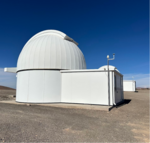
This master project aims to estimate time series of atmospheric water vapor from low-cost GNSS observations and validate the results using observations from a water vapor radiometer. The datasets are collected at the astronomical observation site Paranal in the Chilean Atacama Desert, where they can be used to correct optical astronomical measurements.
Keywords
GNSS Meteorology, Integrated Water Vapor, Water Vapor Radiometer
Labels
Semester Project , ETH Zurich (ETHZ)
Description
Goal
Contact Details
More information
Published since: 2025-10-16
Organization Space Geodesy (Prof. Soja)
Hosts Soja Benedikt
Topics Engineering and Technology , Earth Sciences
Exploring 16 years of global zenith wet delay (ZWD) data

This project focuses on analysing 16 years of GNSS-derived zenith wet delays (ZWDs). The primary aim is to compute long-term ZWD trends and anomalies, characterize their spatial and temporal variability, and investigate the relationship of ZWD with the El Niño Southern Oscillation (ENSO) index.
Keywords
GNSS, zenith wet delay (ZWD), trend and anomaly analysis, ENSO
Labels
Bachelor Thesis , ETH Zurich (ETHZ)
Description
Goal
Contact Details
More information
Published since: 2025-10-15
Organization Space Geodesy (Prof. Soja)
Hosts Soja Benedikt
Topics Engineering and Technology , Earth Sciences
VLBI local baseline observations at the Geodetic Observatory Wettzell

To provide the geodetic infrastructure necessary for monitoring the Earth system and for Global Change research, an end-to-end redesign of the current geodetic VLBI operations called the VLBI Global Observing System (VGOS) is underway. In this framework, new radio telescopes are constructed worldwide. These new telescopes form an independent network that has to be linked to the legacy station network that already has a decade-long observing history. The Geodetic Observatory Wettzell is equipped with three radio telescopes, one 20-meter large legacy antenna that has been operational since 1983 and has contributed the most VLBI measurements worldwide, as well as two new 13-meter large VGOS-style telescopes. By using specially designed VLBI observation sessions between these three telescopes, it is possible to calculate the local baselines between the telescopes with highest accuracy, helping to link the legacy network to the VGOS network.
Keywords
VLBI, scheduling
Labels
Bachelor Thesis , ETH Zurich (ETHZ)
Description
Goal
Contact Details
More information
Published since: 2025-08-18
Applications limited to ETH Zurich
Organization Space Geodesy (Prof. Soja)
Hosts Soja Benedikt
Topics Engineering and Technology , Earth Sciences
Automated VLBI data analysis pipeline
Over the past four decades, Very Long Baseline Interferometry (VLBI) data analysis has relied heavily on manual processing by various analysts, introducing inherent human biases and leading to inconsistent results. Automating VLBI analysis stands to revolutionize this field by not only simplifying the workflow but also significantly enhancing the quality and consistency of data interpretation.
Keywords
VLBI, data analysis, automation
Labels
Master Thesis , ETH Zurich (ETHZ)
Goal
Contact Details
More information
Published since: 2025-08-18
Applications limited to ETH Zurich
Organization Space Geodesy (Prof. Soja)
Hosts Soja Benedikt
Topics Engineering and Technology , Earth Sciences
Data Screening and Homogenization of Long-Term GNSS-based PWV Products
Developing efficient and effective pipelines for implementing advanced data screening and homogenization methods to obtain clean and homogenized long-term GNSS-based precipitable water vapor time series.
Keywords
GNSS, PWV, data screening, homogenization
Labels
Semester Project , Bachelor Thesis , ETH Zurich (ETHZ)
Description
Goal
Contact Details
More information
Published since: 2025-08-18
Applications limited to ETH Zurich
Organization Space Geodesy (Prof. Soja)
Hosts Soja Benedikt
Topics Engineering and Technology , Earth Sciences